NORTHEAST ASIAN HISTORY FOUNDATION 07/2021
-
Yoon Tae-ok, freelance writer
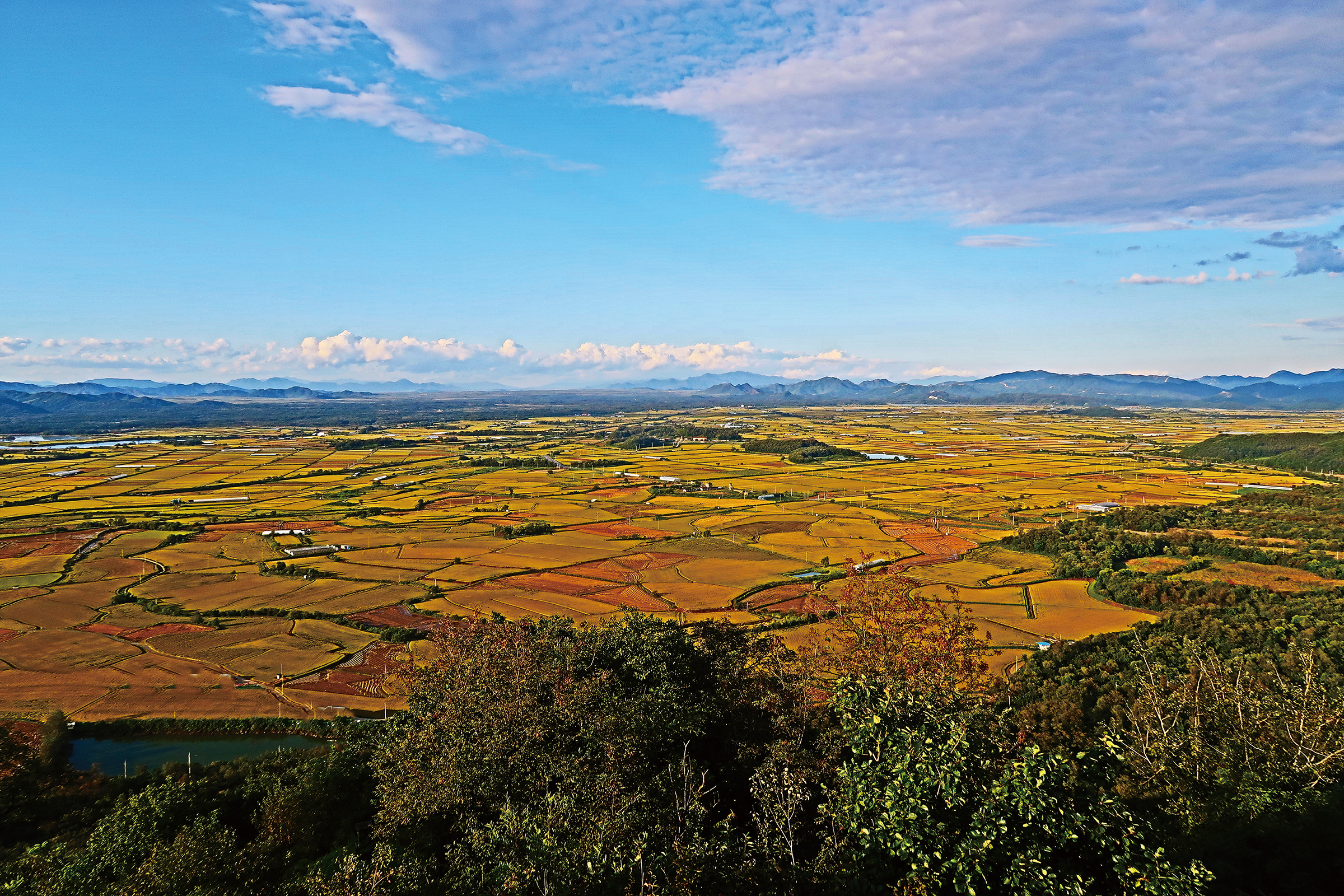
the appearance of Cheolwon plain
Cheolwon is a granary area with a large plain, which both Koreas considered strategically important.
The battle of the Shangganling was fought in the east of Cheolwon Plain.
The site where the armistice agreement was signed is Panmunjom. But today's scene as defined by the armistice agreement is the MDL. History is not only in academic books and papers, but also in the field. Sometimes it becomes a place to travel. A traveler has visited the MDL more than ten times in 50 days. Let's listen to the stories of the three sites he chose, and the Korean War.
I have enjoyed the pleasure of reading history and getting knowledge and information from my age of 50. But I became aware that my knowledge and information were mixed with prejudice and ignorance. So I was afraid of speaking and writing. It was not a big problem to say that I do not know about the history of other countries. But not knowing about the history of my country was a big problem. Especially, the part about the independence movement and the Korean War was even more problematic.
As I took a step into the history of the independence movement, I realized that it was directly related to the Korean War. I spent four years searching for the traces of the independence movement of Koreans in China and organizing it in writing and photography. And I have been searching for traces of the Korean War in the past year, exploring many places in Korea. I visited the MDL in Kyodong-do, Gyeonggi-do and Goseong, Gangwon-do for 5 times in 36 days. And I went to island area of the West Sea with Baekryeong Island, Daecheong Island, Socheong Island and Yeonpyeong Island for 3 times in 13 days. In addition, I explored the 38th parallel area for 3 days, and visited Kyodong Island, Cheolwon and Daejeon several times.
Covid-19 and African Swine Fever prevented me from entering the DMZ. However, there were many traces of the Korean War in the border area. Now I recall the memories of the three most impressive places.
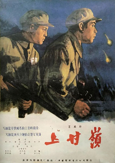
A Poster of the Chinese Film
Do you know Shangganling?
The most impressive place is the 'Monument to the Military Achievement of Battle of Sniper Ridge'. It is located in the south of Kimhwa Bridge, which crosses Namdaecheon in Kimhwa-eup, Cheolwon-gun, Gangwon-do. And it is a small park built in an open area. There is a Chinese film 'Shangganling' produced in 1956. This is based on the battle that took place in the small pass 'Shangganling' of the DMZ in the north of Kimhwa-eup.
At the time, the area was occupied by Chinese troops. There was a road from Shangganling in the north to Hangganling in the south. The west side of the road was called 'Triangle Hill' and the east was called 'Sniper Ridge'. Triangle Hill was taken by the 7th Division of the US Army, and Sniper Ridge was taken by the 2nd Division of the Armed Forces, and UN forces started the attack. The battle lasted from 14 October to 24 November 1952. During the day, UN forces captured the enemy's fortress on the hill with air bombardment and ground shelling, and at night the Chinese raided and took it back. The fierce and miserable battles were repeated every day, so that it could be called ‘the saw of death’. Eventually, the US Army suffered numerous casualties. And they took over the operational area to the 2nd Division of the Armed Forces and withdrew. U.S. public opinion condemned the situation. "The US Army is broke down on the Korean front because of the unjustified war."
How much damage did both sides suffer from this war? And how much did they achieve? Let's look at the damage each side has compiled. UN forces had 7,000 casualties, and Chinese troops had 11,500 casualties. So could the UN forces with fewer casualties have been superior to Chinese troops? Can you say that the UN forces that captured two of the six fortresses won about 33 percent? Separating the Battle of Sniper Ridge, Chinese troops have forced the world's strongest US Army to withdraw, and worsened domestic public opinion in the United States. So it may be that the Chinese troops has won completely. But the end of the battle does not mean the end of the war. As long as history continues, the war of memories continues. The perspective, interpretation and arguments of war may be different. Each country chooses the proper materials according to its position. To highlight national pride, the United States will put Operation Chromite ahead, while China will summon Battle on Shangganling. If China mentions Battle on Shanganling, we will only emphasize Battle of Sniper Ridge, except Battle of Triangle Hill.
I learned the Korean War as 6·25 Cataclysm or 6·25 War. Since North Korea has caused a full-scale war, it means that they should be all responsible. The names that each country has called this war are different. The United States used the name of the country that dispatched its army for the war name, so they call it 'Korean War'. North Korea called it 'The Liberation War' and China called it 'The War to Resist the U.S. Aggression and Aid Korea'. But now, the names 'Korean War', 'Joseon War' are the most used.
The 38th Parallel Sign, Made Jointly by U.S. and Soviet forces
The second most impressive is the 38th parallel. The Korean War began because of the 38th parallel, and hostility was stopped because armistice agreement were signed in the MDL. To be honest, I knew that the 38th parallel and MDL were different only after I explored MDL.
The westernmost part of the 38th parallel that travelers can explore is Mahyeon-ri, Baekhak-myeon, Yeoncheon-gun, Gyeonggi-do. It is located about 3.6km in the west-northwest direction of the royal tomb of King Gyeongsoon. It is DMZ from the back fence of the royal tomb of King Gyeongsoon. So civilians cannot enter there. The sign engraved with the phrase 'Ah! 38th parallel' on a large stone is located at 453-1, Tongguri, Baekhak-myeon, Yeoncheon-gun. The road name address is Cheongjeong-ro 188beon-gil. The sign is on Route 371, so it's easy to find.
If you follow the 38th parallel and go east, you can see a meaningful sign in Choseong-ri, Cheongsan-myeon, Yeoncheon-gun. ‘The monument to the Breakthrough of the 38th Parallel’ was built on 28 May 1951. This marks the third breakthrough of the 38th Parallel by the UN forces. The monument is engraved with the following sentence.
THE FLOWER OF SOLDIERY
PASSED THIS WAY
28 MAY 1951
THIRD CROSSING
OF
38 PARALLEL N. LATITUDE
BY THE
1st CAVALRY DIVISION
UNITED STATES ARMY
ATTACHED TROOPS
70th TANK BN
191st CIC DET
GREEK EXPEDITIONARY FORCE
1st BN 21st THAILAND INFANTRY
IN COMMEMORATION OF THE GALLANT
UNITED STATES GREEK AND THAILAND
SOLDIERS WHO LOST THEIR LIVES
ON THESE OPERATION IN
DEFENSE OF LIBERTY
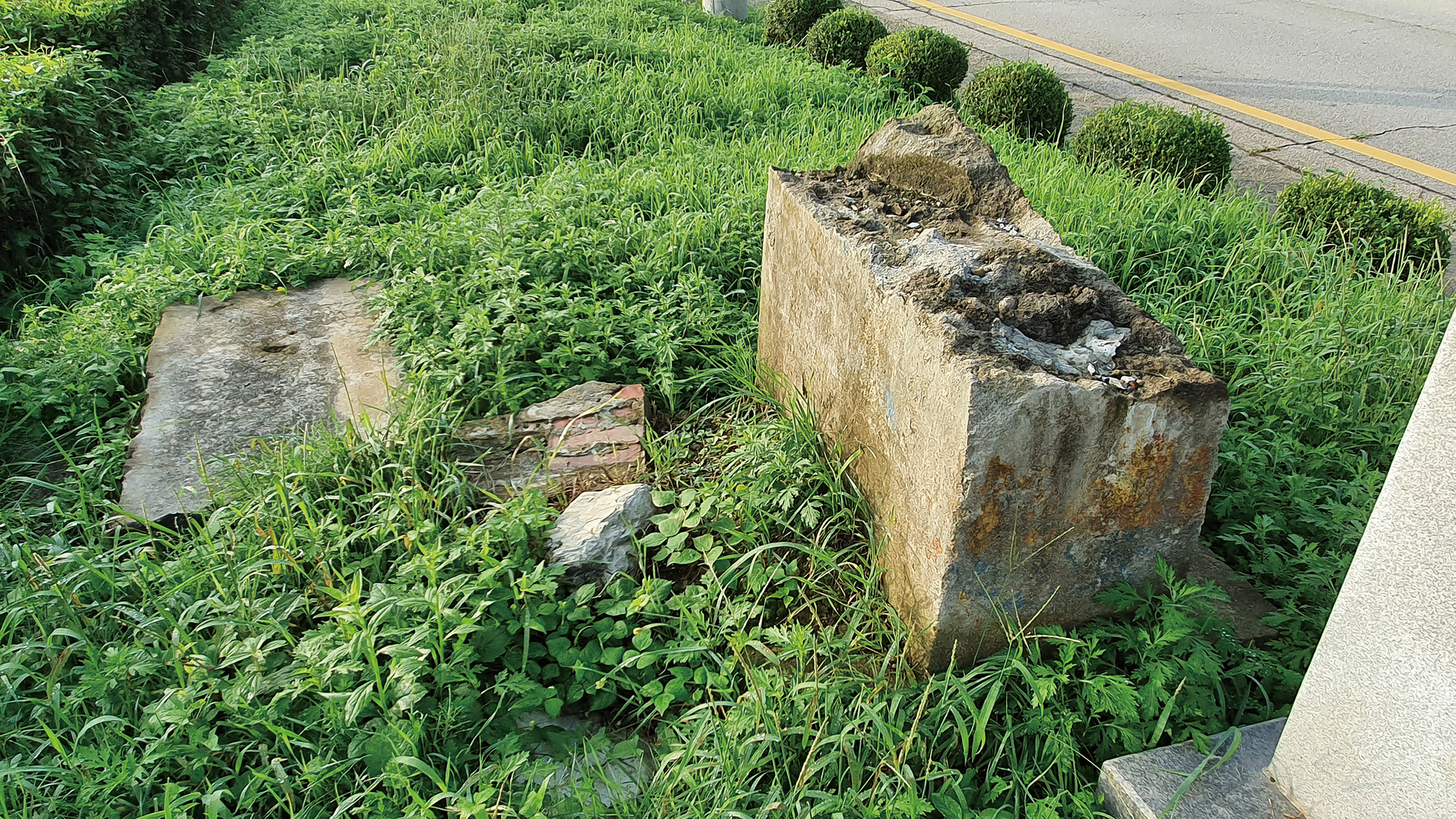
The 38th Parallel Sign, which was jointly established by the U.S. and Soviet forces.
This is in the south of the Hantan River.
Next to this monument is a sign made of natural stone. But what the notice explains is not the sign, but the old concrete standing next to it. Upper is laid on the floor with a cut, and the bottom is embedded on the ground. This is the 38th parallel sign, which was jointly made by the U.S. and Soviet forces in 1945, and the contents of the notice show its history.
The damaged old 38th parallel sign was built on August 15, 1945, after the liberation, under the agreement of the United States and the USSR. Kim Il Sung invaded the South on June 25, 1950, at 4 am with the People's Army and tanks. The Korean War is a bloodied war that sacrificed many Korean troops and civilians. This caused the historic '38th parallel sign' to be damaged. So on September 17, 1991, the governor of Yeoncheon-gun, Hong Seong-gyu, erected the border stone of the 38th parallel next to it. The damaged old sign was to be preserved as a monument as it was damaged.
April 2016
The Yeoncheon branch of the Korean War Veterans Association
The 38th parallel is not the line we agreed to. We did not know when the United States and the Soviet Union discussed and decided. So, the sign that the two countries' armies agreed to build is the most consistent with historical facts and meanings. I never thought I would actually see the 38th parallel sign set up by the U.S. and Soviet forces. I just went to see the monument to the breakthrough of the 38th parallel, and I accidentally met the real ruins next to it. It was nice and amazing. And on the one hand, my heart was about to burst. This is because the Japanese colonial period was replaced by the occupation of the winner of the World War. Of all being there, the most valuable was the damaged concrete. 38 degrees north latitude exists only on the map, and it is a concept that is known as a surveyor. However, after the 38th parallel became a political and military demarcation line, new words such as 'defect from North Korea' and 'defect from South Korea' came up. And when the 38th parallel sign was built, it became a special act to pass through here.
Before the division changed the times and environment, there would have been more roads to Mt. Geumgang. During the Japanese colonial period, Hantan Railway Bridge was on its way to Mt. Geumgang. The railway line to Mt. Geumgang is connected to Gyeongwon Line and Geumgangsan Line. First, Gyeongwon Line starts from Yongsan and runs in the order of Seobingo-Wangsimni-Cheongryangri-Changdong-Uijeongbu-Deokjeong- Dongducheon-Jeongok-Yeoncheon-Daegwangri–Cheolwon. Then, it runs to Woljeong-ri, Pyeonggang-Bokgye-Gumbulang-Cell-Sambang-Gosan-Yongji-Sukwangsa-Namsan-Anbyon-Baehwa-Galma-Wonsan. There are many unfamiliar names of a place. In addition, the Geumgangsan Line is divided from Cheolwon and heads to Mt. Geumgang. The line runs to Cheolwon-Sayo-Wolha-Daewi-Jungyeon-Geumgok-Kimhwa-Ashim-Geumseong-Gyeongpa-Gyeongpa-Changdo-Hyunri-Hwagye-Danbalyeong-Malwhiri-Naegeumgang. There are 28 stations in total. Cheolwon to Kimhwa is a South Korean region, and from Ashim to Naegumgang is a North Korean region.
Looking at the map of Korea, Cheolwon, which is divided into Mt. Geumgang, is located in the navel. Let's look at the map with the railway line. The line connecting Shinuiju, Seoul and Busan, and the line connecting Cheongjin, Wonsan, Seoul and Mokpo cross X-shaped. Of course, Seoul is the center of the railway. However, think of the railway as an artery, and imagine the land as a body. Cheolwon will look like a belly button.
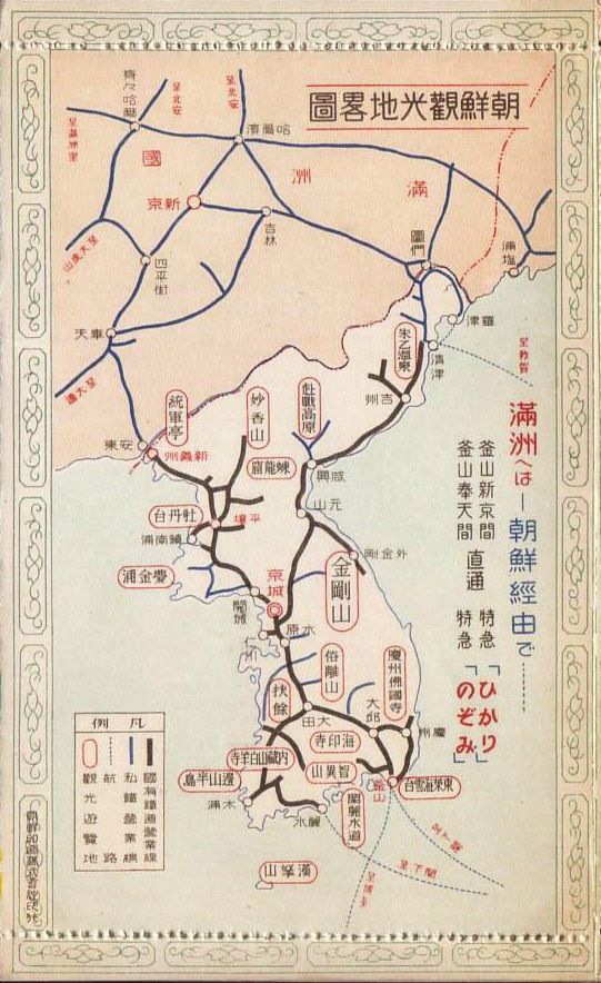
1930s railway linemap
Cheolwon is in the middle of Gyeongseong and Mt. Geumgang.
It is at the center of the Korean Peninsula.
The Way to Mt. Geumgang: Railway and Land Route
There is another land route to Mt. Geumgang. It is a road to Malwhiri, an area close to the terminus of the Geumgangsan Line. Malwhiri was a strategic point where the trains coming and going in the east-west direction and the roads extending north-south direction crossed. The north side of the area is Wonsan, and the south side is connected to Chuncheon through Yanggu. The road from Naegum River to Onjeong-ri near the Oegum River also starts from Malwhiri.
'I go to Mt. Geumgang.' was the same word as 'I go to Malwhiri.'. People had to use the Gyeongseong-Orijin line to go from Gyeongseong to Malwhiri. This road connects to Orijin(Now, Ohori, Jukwang-myeon, Goseong-gun, Gangwon-do) through Gyeongseong-Yangpyeong-Chuncheon-Yanggu and connects Seoul and the East Sea. First, we use the Orijin line to go to Gyeongseong. Then go from Chuncheon to Yanggu and use Yanggu-Malwhiri route. Chuncheon-Yanggu-Malhui-Wonsan was the axis of traffic, economy and everyday life in this area. Generally, most goods or information supplied to Yanggu has moved from Wonsan. After the war, the road was completely blocked, and the link with Chuncheon became stronger.
The division swallowed everything and poured it out. And we lost a lot. Armistice regimes are a mixture of anxiety and militancy. Many things have been forgotten in the scab of the wound in the regime. The Naegeumgang Line, which connected Chuncheon-Yanggu-Malwhiri, disappeared. The section between Chuncheon and Yanggu became part of Route 46. So it is hard to guess the old geography with the current name. The section between Yanggu and Malwhiri was changed to Route 31. The current road name address is 'Geumgangsanro'. Thanks to that, we can learn a little about the geography and traffic before the division.
In January 2021, I visited MDL and suggested to my friends. "Let's go to the end of Route 31." They readily accepted my offer. When we drove, the end of Route 31 was bideuggogae(also known as bidulgigogae, guhyeongogae). The checkpoint of the civilian control line were at the highest point in the bideuggogae. We could not pass the civilian control line. So we took a few pictures there and then came back. We had a little sense of accomplishment that we had gone to the end as far as we could. But there was also a deep sigh of 'the road is blocked'.
Bideuggogae is one of the sites where civilians were slaughtered during the Korean War. There was no place without a massacre. In Yanggu, civilians were slaughtered in the valley behind the current Yanggu Police Station, and there was the same tragedy in the bideuggogae on the way to Wonsan.

The user can freely use the public work without fee, but it is not permitted to use for commercial purpose, or to change or modify the contents of public work.
- Northeast Asia History Network
- Northeast Asia History Library
- DOKDO Research Institute
- DOKDO Museum Seoul
- Education and Training