NORTHEAST ASIAN HISTORY FOUNDATION 05/2009
-
HONG Seong-Keun Research Fellow Dokdo Research Institute
Dokdo is visible!
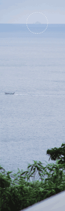
"Dokdo has long been Korean territory." The veracity of this statement is something I first grasped with my heart than with my mind. One spring day in May 1985, I stood atop Manghyang Peak overlooking downtown Dodong of Ulleungdo. My vision is not that great, but afar, in the middle of the ocean, I clearly saw Dokdo, which resembled the humped back of a camel. I got to see Dokdo before I had set foot in it. Back then, I did not know about Mangi Yoram [Book of Ten Thousand Techniques of Governance], the "Dajokan Directive," or any other textual record that proved Korea's historical sovereignty over Dokdo. And yet, my heart knew that Dokdo had always been a part of Korea.
They say people have been living in Ulleungdo since the 6th century. How could they not have known about Dokdo, which is visible to the naked eye? For Ulleungdo residents, it is no news that Dokdo is always within sight. They can see it when they are on a stroll, when they are working in the fields, and when they are picking herbs in the woods. One may not know about the reference to Dokdo in "Sejong Sillok Jiriji" [Geographical Appendix to the Annals of King Sejong] of the 15th century: "It is visible on a clear day with the right winds." One need not refer to the written record left behind by JANG Han-sang, the provincial government official of Ulleungdo: "An island is faintly visible to the southeast of Ulleungdo." The fact that Dokdo is visible from Ulleungdo is unequivocally evident.
Way back, a so-called Dokdo expert even resorted to complex mathematical formulas to prove that Dokdo cannot be seen from Ulleungdo. No matter how grandiose these formulas were, there is no denying that Dokdo is visible from Ulleungdo.
Starting in July 2008, the Dokdo Research Institute of the Northeast Asian History Foundation undertook a survey, observing and capturing images of Dokdo from Ulleungdo. The goal was to demonstrate that Dokdo had always been a part of the everyday lives of Ulleungdo residents.
The surveyor made most of the observations from a village located in the upper reaches of Dodong-ri, which is at 270 m above sea level, lower than the aforementioned Manghyang Peak (317 m). The photographs taken by the surveyor feature Dokdo against diverse backgrounds, including a persimmon tree in the front yard of a house, a roadside, and a telephone pole standing in someone's front yard.
May 18 Photo Exhibition: Dokdo as Seen from Ulleungdo
Some people visit Ulleungdo in order to see Dokdo, but those who are unlucky may wait days and never catch a glimpse of the island. This is because, as recorded in "Sejong Sillok Jiriji," Dokdo is only visible on a "clear day with the right winds."
In the summer, there is a lot of fog in and around Dokdo. A better time to spot Dokdo is in the spring or fall (especially in November) when there are gusts of cold wind. On average, Dokdo is visible from Ulleungdo more than three days per month. In terms of the time of the day, the early morning is better than midday. I recently saw Dokdo in real time via a web camera set up at the Dokdo Observation Tower in Ulleungdo, accessible on the website of the Ulleung-gun Office.
The Dokdo Research Institute is organizing a photo exhibition entitled "Dokdo as Seen from Ulleungdo," featuring the images and videos captured during the survey. The exhibition will be held at the National Assembly Members' Office Building Lobby and then at the National Assembly Library from May 18 to 29. It is hoped that the images and videos of Dokdo amidst the natural landscape and everyday life of Ulleungdo bring Dokdo even closer to people's hearts.
- Northeast Asia History Network
- Northeast Asia History Library
- DOKDO Research Institute
- DOKDO Museum Seoul
- Education and Training