NORTHEAST ASIAN HISTORY FOUNDATION 10/2014
-
Written by Oh Sang-hak, Professor at Jeju National University
With the increasing public interest in Dokdo, news articles related to Dokdo cover various contents unlike in the past. There is a deluge of articles from a variety of areas, including international politics, certain politicians' behaviors in relation to Dokdo, the ecology and the life of residents of Dokdo, and the Dokdo issue related to national defense. Quite a few of these articles feature old maps related to Dokdo.
With the increasing importance of old maps as evidence of sovereignty and the discovery of Dokdo-related old maps at home and abroad, the press reveals these maps as evidence confirming our sovereignty over Dokdo. Since they can visually attract public attention, articles featuring old maps often appear not only in central daily newspapers but also in local newspapers, online media, and national TV.
While these articles play a positive role in hammering Korean sovereignty over Dokdo home to the public, some of them have problems with their content because they rely solely on the informant‘s opinion without consulting experts in the field for verification.
News articles on Dokdo-related old maps by central daily newspapers, local daily newspapers, and online newspapers have been on the rise since the 1990s, but they have fluctuated significantly by year, depending on whether there were Dokdo-related issues that year. In 1996, the year in the 1990s that saw the largest number of related articles, demarcation emerged as an important issue as both Korea and Japan declared an EEZ extending 200 nautical miles. Furthermore, when the Japanese government. laying claims to Dokdo, demanded that its Korean counterpart should withdraw the Dokdo Guard and cancel the planned construction of a new berth facility, the anti-Japanese sentiment among the Korean people reached its peak, and there was also an explosive growth of Dokdo-related articles.
In 2005, the Shimane Prefecture Council of Japan enacted an ordinance to establish what they called 'Takeshima Day.' In 2008, the Library of Congress made a preliminary decision to remove 'Dokdo' from the keywords and called a meeting. During this period, the U.S. Board on Geographic Names reclassified Dokdo as 'a region of undesignated sovereignty.' This caused quite a stir in Korea because it was perceived as a symbol of threat to Korean sovereignty over Dokdo.
The recent years of 2012 and 2013 also saw a great increase in the number of articles. In 2012, Korean President Lee Myung-bak's visit to Dokdo became an issue. In 2013, the Shinzo Abe administration's strong claims to Dokdo led to a great in crease in articles on Dokdo-related old maps.
Problems with Errors in Articles on Old Maps
The news articles about Dokdo-related old maps that came out from the 1990s onward are generally divided into three types: Korean old maps, Japanese old maps, and Western old maps. Of the three types, an overwhelming majority are articles about Japanese old maps. There are not many new articles about Korean old maps because they already became widely known before. And there are not many Western old maps that include Dokdo, except the series of maps by the French cartologist D'Anville. In Japan, on the other hand, in the course of its imperialist expansion, many maps were made by national institutions or in the private sector. And most of these maps marked Dokdo as Korean territory. In particular, maps or geography textbooks made in the early 1900s also confirm Korean sovereignty over Dokdo. As the Japanese old maps were made public, many news articles followed. While these articles play a positive role in helping the general public better understand the historical title to Dokdo, some of them have erroneous content. Problems with these articles large fall into one of the following three categories.
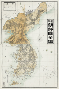 The New Complete Map of Korea
was made by Josho Tanaka
(田中紹祥) in 1894, and it has
been introduced to Korea many
times. In this map, Korea and
part of Japanese territory are
drawn, and Korean territory,
including Jejudo, Ullengdo,
and Dokdo, is colored entirely
in yellow.
First, the informant's view is reported lopsidedly without thorough verification by an expert. Unlike the old document, the old map is visual material and, therefore, relatively easy for laymen to understand. However, geographical names or map contents are still difficult to understand without expertise. Therefore, when the informant's view is presented in a press release, it must be verified by an expert. Such verification needs to be done more thoroughly, particularly when the map is not widely known, in order to keep false reports to a minimum.
Secondly, a map that has been already made public and also widely known in the academia is reported as though it was a new discovery. This usually happens when the press is greedy for 'news items.' A good example is the press coverage of the New Complete Map of Korea made in Japan. Already introduced in Korean educational books on Dokdo, this map is far from a new discovery. Reporting that it is a new discovery without verification simply because the informant said so cannot be responsible journalism.
Thirdly, the article lacks objectivity and tends to be overly nationalistic. The article's vital elements are fairness, objectivity, and factuality. Appealing matters concerning the territorial issue to nationalism that inspires national sentiment is a stumbling block that prevents the public from gaining a complete understanding of the territorial issue. There are also cases where the article reflected the reporter's own interpretation, most notably interpreting 'Kanran (韓唐)' on complete maps of Japan as Dokdo. Such reporting is seriously problematic because it could invite attack from Japan. Instead of stopping at false reporting, it could be taken advantage of by Japan in arguing that Korea was making false claims.
Need to Secure a Database of Old Maps Covered by the Press
Once released, news articles stay there forever. Finding old articles online is easy these days. This means that the false report is a problem that not only simply concerns the reporter or the informant but undermines the credibility of Korea. Therefore, when writing articles, it is essential to use care and seek thorough verification. To this end, compiling old maps covered by the press into a database is absolutely needed at this point. It is necessary to not only secure high-resolution images of old maps covered by the press but also use them for detailed analysis of those old maps as important evidence of sovereignty. Once such a database is in place, it is expected to be put to good use in press coverage in the future.
- Northeast Asia History Network
- Northeast Asia History Library
- DOKDO Research Institute
- DOKDO Museum Seoul
- Education and Training