NORTHEAST ASIAN HISTORY FOUNDATION 12/2014
the Cover
Maps are an extremely important part of our heritage in that they show us the boundaries of the world and territory as perceived by people at the time. A map made in the late 18th century, 'Agukchongdo (我國總圖: meaning Complete Map of Our Country) follows the Principle of Five Elements, marking the names of counties and prefectures in five colors corresponding to their five points on the map: Blue for the East (Gangwon Province); White for the West (Hwanghae Province); Red for the South (Jeolla and Gyeongsang Provinces); Black for the North (Hamgyeong Province); and Yellow for the Center (Gyeonggi and Chungcheong Provinces). This map expressed the mountains, rivers, and seas with attention to detail, even marking the names of small islands. The seas were marked as the East Sea, the West Sea, and the South Sea, according to their location. And Dokdo was marked as Usan (于山). The map contains an interesting note that reads: "Given a favorable wind, it is only two days' sail from land to Ulleungdo."
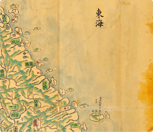 Photo 1 An enlarged view of the East Sea portion of Agukchongdo
- Northeast Asia History Network
- Northeast Asia History Library
- DOKDO Research Institute
- DOKDO Museum Seoul
- Education and Training