동북아역사재단 2022년 06월호 뉴스레터
- Baek Jong-oh, Professor at Korea National University of Transportation, Head of the Central Field Studies Research Institute
Han River and Hanseonggi and Ungjingi of Baekje
The Hangang River Basin is a transportation route that crosses the central part of the Korean Peninsula and is a granary that embraces a vast plain. Also, due to its importance as a starting point of transportation to China, it has been the background of varied fortunes of the nation since ancient times.
According to the Records of Baekje section of the Samguk Sagi (History of Three Kingdoms), Baekje had its capital located by the Hangang River Basin from 18 BC to 475 AD in Gongju by the Geumgang River Basin until 538, and in Buyeo until 660 AD, for which the historical period of Baekje is divided into the Hanseong Period, Woongjin Period, and Sabi Period. In 396, King Gwanggaeto of Goguryeo crossed the Arisu river and attacked the royal fortress of Baekje. King Jangsu of Goguryeo attacked Hanseong in 475 and killed King Gaero. According to historical sources, King Seong of Baekje, along with Silla and others, defeated Goguryeo in 551 and was able to capture Hanseong. In other words, from 475 to 551, Goguryeo occupied the Hangang River Basin, which is something we are accustomed to accepting through textbooks. But I wonder if that is really the case.
Goguryeo’s Defense Network and Transportation Routes
Goguryeo formed an individual defense network composed of gwanbang, such as mountainous fortresses and bastions, and planned to rule the territories expanded during the conquest through a military organization consistent with the local administrative organization. The main base of Goguryeo was built on the main transportation routes where they could move and respond to the enemy quickly. In other words, they created an environment in which the influence of Goguryeo could be exerted in the area centered on the natural transportation routes formed around rivers, streams, and tributaries.
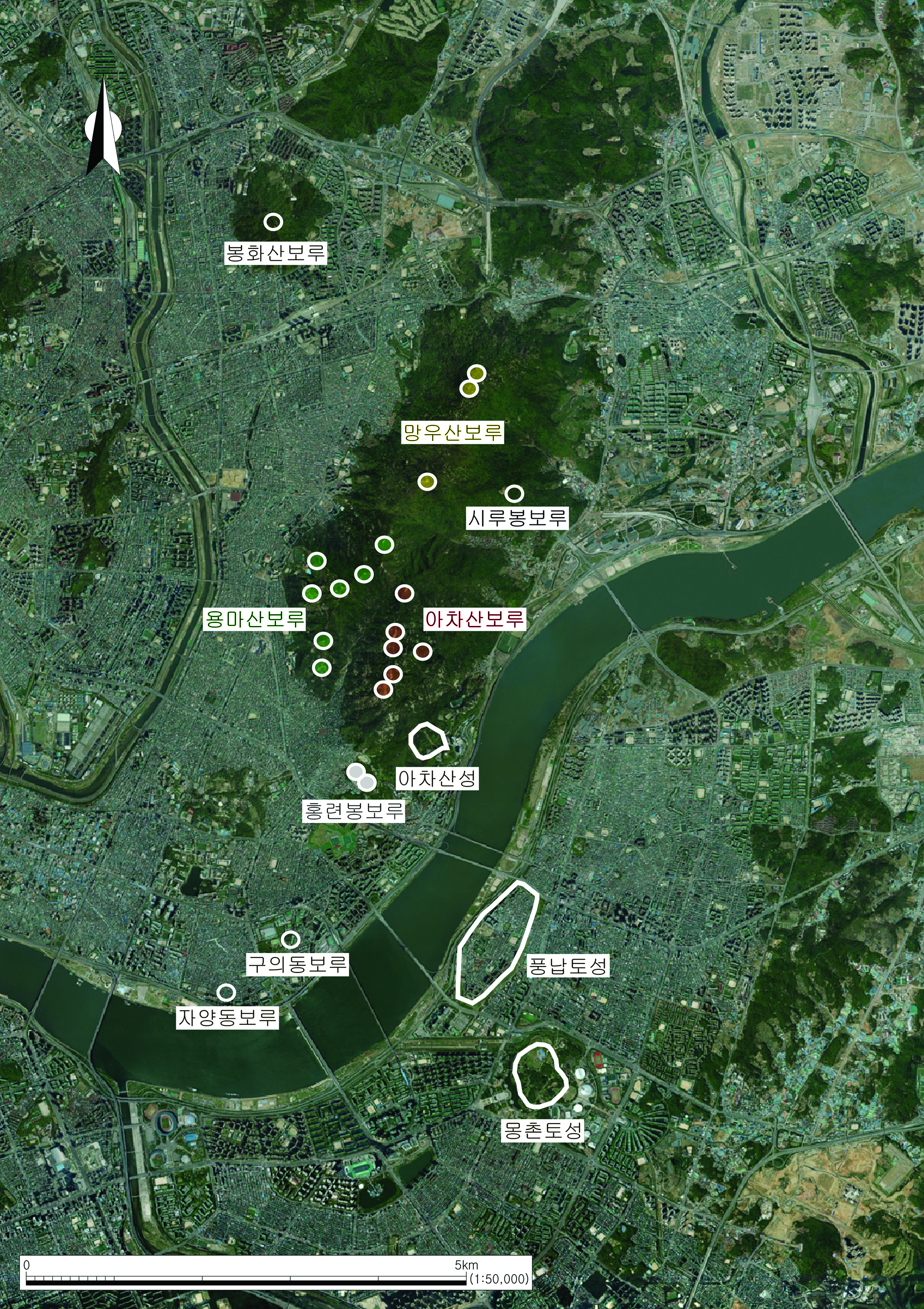
Goguryeo Bastions and Burial Mounds in the Hangang River Basin
The ruins of Goguryeo in the Hangang River Basin are concentrated in the Achasan Mountain area. It does not run beyond Wangsukcheon Stream in the east and Jungnangcheon Stream in the west. It occupies a geopolitical location that can control the Hangang River in the south and Pungnaptoseong Fortress and Mongchontoseong Fortress in its vicinity. In the Imjingang River Basin, there are many medium and large-scale flatland fortresses, such as Horogoruseong Fortress, Eundaeriseong Fortress, and Dangposeong Fortress. However, most of the fortresses in the Hangang River Basin are small military fortresses with a circumference of 300m or less. Goguryeo fortresses in the Hangang River Basin is located at Yongmasan Mountain, Hongryeonbong Peak, Shirubong Peak, and Bonghwasan Mountain, which are the same main ridges as the main ridge from the top of Achasan Mountain. Currently, 17 places are designated as national historic sites.
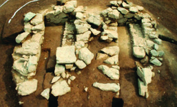
Bastions 3 and 4 of Achasan Mountain, Bastions 2 of Yongmasan Mountain, Bastions 1 and 2 of Hongryeonbong Peak, Shirubongboru Bastion, and Guuidongboru Bastion were excavated. Commonly identified remains include fortress walls, battlements, building sites (residences), ondol (underfloor heating system), water storage facilities, and drainage channels. Other facilities include blacksmiths, smithing facilities, mills, earthenware kilns, and burned remains. The interesting aspect of the ruins of Goguryeo in the Hangang River Basin is that a large-scale fortress or flat fortress, such as a base fortress, was not built.
It is strongly deemed that the bastion served as a small military facility like GPs (Guard Posts) and GOPs (General Outposts) in the current demilitarized zone and surrounding areas. Facilities, both inside and outside, meet the minimum necessary conditions for living. This clearly shows that battles took place frequently, and the occupants of the fortifications changed in the course of these battles. At one time, it had been a fortress at the front line for Goguryeo, a location that placed a considerable burden on Baekje, making it easy to guess that fierce battles took place several times in a short period of time. Even now, the thought of battles from those days raises tension when I climb Achasan Mountain. In the end, it had to be a temporary rather than permanent occupancy.
Other Goguryeo remains in the Hangang River Basin include the site of a stone base building site, stamped earth site, ondol building site, Garak-dong Tomb No. 5 with Goguryeo tiles on the floor, Bojeong-dong, Dongcheon-dong, and Eobiri tombs near Tancheon stream, Pangyo-dong tombs in Seongnam, and Mabuk-dong in Yongin where Goguryeo earthenware was retrieved, the residence site of Geondeung-ri in Wonju, the Goguryeo earthenware excavated from the upper part of the Baekje residence in Tappyeong-ri, Chungju, six burial mounds in Dujeong-ri Tombs in Chungju, and the Tombs No. 5 and 10 in Danwol-dong in Chungju. In the case of Goguryeo tombs, there are usually 1 or 2 burial mounds per site, and only the six burial mounds in Dujeong-ri, Chungju are arranged horizontally.
Meaning of Goguryeo Convex Tiles Excavated from Bastion 1 of Hongryeonbong Peak
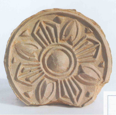
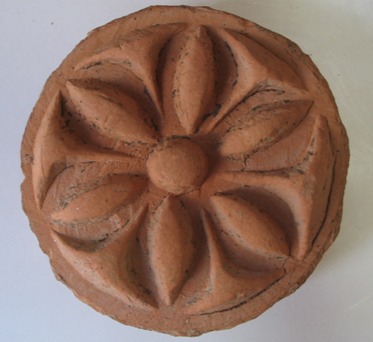
Bastion 1 of Hongryeonbong Peak drew attention because it is the only bastion where roof tiles were unearthed among the bastions of the Achasan Mountain area. As for the roof tiles, most of them were red and gray straw rope patterned flat tiles. In addition, the convex tiles with lotus patterns were excavated for the first time in the Hangang River Basin. It was only found in Horogoruseong Fortress in the Imjingang River Basin.
In the Goryeo Part of the Dongi Section of 『The History of Tang Dynasty』, it is recorded that “Most of the roofs were covered with rice sheaves, but tiles were used for Buddhist temples, shrines, royal palaces, and government offices.” This indicates that the roof tiles were used only for special buildings such as the royal palace, government office temples, and shrines, which are state-related buildings. As such, it can be said that the roof tile is an architectural member that symbolically represents the hierarchical order through the dignity and decorativeness of the building itself.
In other words, Bastion 1 of Hongryeonbong Peak and Horogoruseong Fortress from which convex roof tiles were excavated become high status remains in the hierarchy. Also, it is highly likely that a ritual similar to the dongmaengjeeui (thanksgiving) of Goguryeo was performed, as it is observed that the peripheral edge of the convex roof tile was damaged and discarded in these relics. In other words, it is necessary to emphasize the meaning of Bastion 1 of Hongryeonbong Peak and Horogoruseong Fortress as ceremonial spaces along with their military functions.
Who Owned the Hangang River Basin in 475-551?
It is necessary to discuss which country occupied the Hangang River Basin from 475 to 551. So far, the 'Theory of Goguryeo Occupation' seems to be the strongest. I would like to ask, ‘Is it because of the bias of archaeological data and its interpretation?’
The excavator definitively supports the ‘Theory of Goguryeo Occupation’ by setting the age of the pottery named with the ‘gyeongja (庚子) mark’ excavated from the Bastion 2 of Hongryeonbong Peak as 520. However, the mark is sometimes read as ‘hoja (虎子)’ rather than gyeongja. Even if you look at the case of the Bastion 4 of Achasan Mountain, most of the marks are people’s names, such as ‘Yeommohyung (牟兄)’ and ‘Jidohyeong (支都兄).’ This is because the pottery was personal dispensers. There are no other examples of engraving the sexagenary cycle on earthenware. It is unlikely that this will be a textual document that confirms the 'Theory of Goguryeo Occupation.’
For this, various opinions such as the ‘Theory of Baekje Occupation,’ the ‘Theory of Recovery during King Dongseong or King Muryeong’s Reign,’ and the ‘Theory of Loss during King Seongwang’s Reign’ are constantly being raised. In particular, the ‘Theory of Loss during King Seongwang’s Reign,’ indicating that Baekje lost the Hangang River Basin when it lost in the Battle of Ogok in Hwanghae-do in 529 and recovered in 551, is worth noticing.
One of the general characteristics of a fortress is its continuous use. In other words, the fortress is used by different subjects depending on the period. As such, it might be necessary to look at the Goguryeo’s ruins in the Hangang River Basin from a broader perspective, as in the record in the Baekje Section of 『The History of the Sui Dynasty』, “People from Silla, Goguryeo, and Japan live together, and there are also Chinese.”

동북아역사재단이 창작한 '한강 유역 고구려 유적 - 우리 곁의 고구려' 저작물은 "공공누리" 출처표시-상업적이용금지-변경금지 조건에 따라 이용 할 수 있습니다.