동북아역사재단 2020년 12월호 뉴스레터
- Kim Jong-geun, Research Fellow at NAHF Dokdo Research Institute
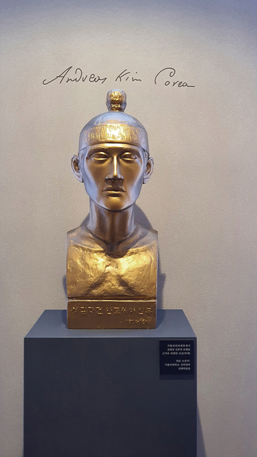
The bust of Father Kim Dae-geon
Geographical name not familiar to foreigners: East Sea
The first passage of the national anthem, which starts with 'Donghae Water and Mt. Baekdu dry and wear out' begins with 'East Sea'. As such, 'East Sea' is a geographical name familiar to the Korean people and is a familiar name for overseas Koreans including North Korea. So what about foreigners? Unfortunately, many maps published overseas often have been recorded as the ‘Sea of Japan’ in the East Sea, so they do not feel familiar with the geographical name ‘East Sea’.
So why do the map books list 'East Sea' as 'Sea of Japan'? This is because the 『Limits of Oceans and Seas』 published in 1929 by IHB(the predecessor of IHO) listed ‘East Sea’ as ‘Sea of Japan’. This is the first book published by the International Organization to collect information on the seas of the world, and it defines the location, area, and name of the seas around the world. For this reason, this book has served as the only international standard for the world's sea name, and overseas map makers have named the sea as described in this book. 『Limits of Oceans and Seas』 were created during the Japanese colonial period. And after the 2nd edition was published in 1937 and the 3rd edition was published in 1953, it continued to become a standard guide for the world's sea name. For this reason, 'Sea of Japan' was used as an international standard name representing the East Sea waters for 90 years.
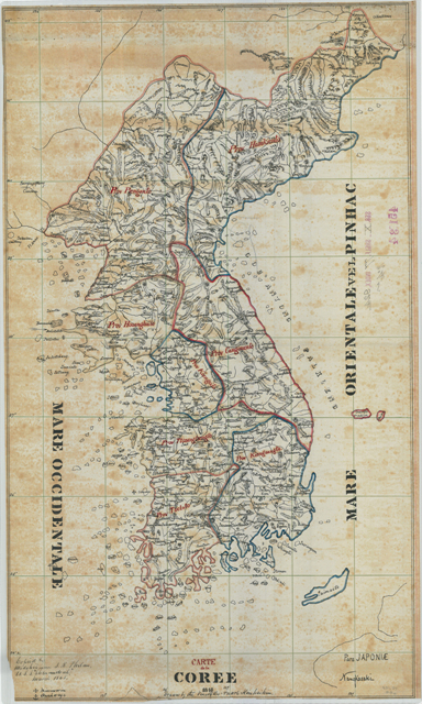
「CARTE de la COREE」(1868)
(Collection: National Archives and Records Administration)
Our efforts and achievements to mark ‘East Sea’
In order to overcome the situation that ‘East Sea’ is listed only as ‘Sea of Japan’, the Korean government has made great efforts over the past 30 years. The Korean government first insisted that ‘East Sea’ should be listed with ‘Sea of Japan’ at the 6th UN Conference on the Standardization of Geographical Names in 1992, shortly after joining the United Nations. And at the 15th IHO General Assembly in 1997, The 4th edition of 『Limits of Oceans and Seas』 required the description of ‘East Sea’ with ‘Sea of Japan’. After that, the UN and IHO demanded that the ‘East Sea’ be marked steadily every time the meeting was held.
Not only the government but also public institutions such as the Northeast Asian History Foundation, private organizations such as VANK and The Society for East Sea, and overseas Koreans are also trying to promote the 'East Sea' notation. As a result, the proportion of 'East Sea' in map books published in major overseas countries as of 2020 exceeded 40%. In particular, the second IHO General Assembly held on November 16th, 『Limits of Oceans and Seas』 remained a publication that shows historical changes from analog to digital, and instead, the introduction of the new standard ‘S-130’ for the name of the sea was decided. This corrected the situation in which ‘Sea of Japan’ was used alone as an international standard name for the ‘East Sea’ waters.
The East Sea, which has been called various names in history
Looking at the ancient maps made in the West, the Korean peninsula and the East Sea waters appear only in the late 16th century. The maps made in the early days included only the Korean Peninsula and the name of the sea was not listed. From the 17th century to the early 18th century, the names such as 'China Sea', 'Oriental Sea' and 'East Sea' were listed in the East Sea waters. After the mid-18th century, it was mainly listed as the 'Sea of Korea'. And from the middle of the 19th century, it was mainly listed as ‘Sea of Japan’, but maps listed as 'Sea of Korea', 'East Sea', and 'Tatar Sea' are also found. As such, there are various names representing the East Sea waters and have changed according to the flow of the times. Geographical names change to reflect the situation of the times. Nevertheless, Japan insists that ‘Sea of Japan’ should be listed alone because it is already 'fixed' in the 19th century.
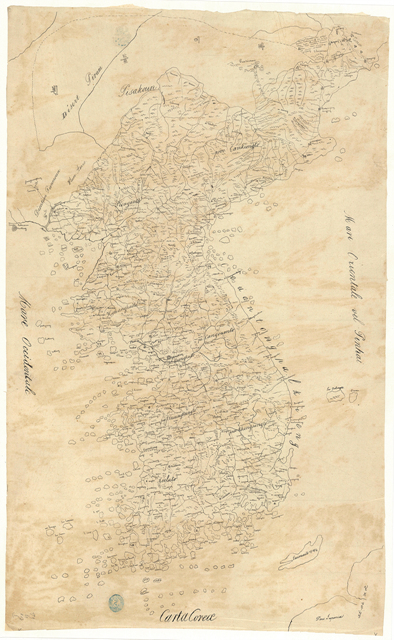
Latin Text 「Carta Corea」(1860)
(Collection: National Library of France)
‘East Sea’ listed on maps published in the 19th century
This year, I found two maps that could refute Japan's claim that ‘Sea of Japan’ was 'fixed' in the 19th century Western map. The first map is 「Carte de la Coree」, which is owned by the National Archives and Records Administration(NARA). This is a copy of the map of Father Kim Dae-geon in 1868 by J.R. Phelan, sent by the US government to investigate the General Sherman case.
The second map is the collection of Bibliothèque nationale de France(BnF), 「Carta Corea」 produced in 1860. The person who produced this map is unknown. However, as a result of analyzing the map, it is judged that the map of Kim Dae-geon was copied. What is encouraging is that the two newly discovered maps are listed in Latin as 'MARE ORIENTALE'(East Sea). The discovery of these maps proved once again that the claim that the ‘Sea of Japan’ was fixed in the 19th century was a low-reliability claim.
Father Kim Dae-geon, who produced maps with the East Sea and Dokdo
In 1978, Choi Seok-woo discovered a map produced by Kim Dae-geon at BnF and introduced it for the first time in Korea. This map shows that Usando(Dokdo) is listed as the territory of Joseon, and it has been widely used as a data to prove the sovereignty of Dokdo. The two maps I discovered this time also copy the map of Father Kim Dae-geon, and it clearly marks ‘East Sea’ as well as Usando(Dokdo), which will be a great help in promoting ‘East Sea’ notation. 2021 is a meaningful year to mark the 200th anniversary of the birth of Kim Dae-geon. UNESCO selected Kim Dae-geon as the UNESCO World Memorial Person in 2021 for his contribution to practicing equality and philanthropy, and in particular to the production of ‘Joseon Jeondo’ and to inform European society. I will devote a flower to his death in honor of the accomplishment of Father Kim Dae-geon, who left a legacy that greatly helped strengthen our territorial sovereignty of Dokdo and promote the East Sea.

동북아역사재단이 창작한 '동해와 독도가 표기되어 있는 19세기 중반 서양 고지도와 김대건 신부' 저작물은 "공공누리" 출처표시-상업적이용금지-변경금지 조건에 따라 이용 할 수 있습니다.