동북아역사재단 2011년 04월호 뉴스레터
- Bae, Seong-jun Researcher, Research Department
Most people will think it is strange if I tell them I went to the US to find records and documents about Gando. Not many people know that a lot of valuable documents about Gando are in the US. In as early as 1904, the US had four Consulates (in Dandong, Dalian, Shenyang, Harbin) in Manchuria, which closely monitored the trends. Also, Japan had to give up on its territorial claim over Gando in 1908 due to the Root-Takahira Agreement which affirmed the territorial integrity of China. To further study these issues and secure documents, I went to the US on December 15 last year and spent 10 days in Boston and Washington DC searching for documents.
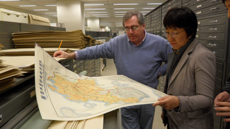
In Boston, I visited the Harvard Map Collection located in Pusey Library at Harvard University. It is the oldest map collection in the US, with early maps of New England and American railway maps. I was fortunate to see some ancient Korean maps and topographic maps drawn under Japan's colonial rule. The map titled "Joseon and Manchuria", created in the US in 1904, and another map titled "Moukden (Manchurian name for Shenyang, China)" clearly showed the roads and water system in the Korean peninsula and Manchuria.
In Washington DC, I went to the Library of Congress and the National Archives and Records Administration. The Library of Congress's Manuscript Division holds documents and records of US Presidents, senior government officials and NGOs, and I scanned through personal records of State Secretaries from 1907 to 1910. Elihu Root, who signed the Root-Takahira Agreement, served as State Secretary from 1905 to 1909, and there were as many as 256 containers filled with numerous records and documents classified into 66,000 subjects. Given the enormous amount of data, I could only look at some of the boxes during my short stay. The Geography and Map Division holds the largest and most comprehensive collection in the world, with more than 5.5 million maps. Korean maps are located in map room, topographic map room, and vaults. Only a handful of them are exposed to public. Ancient maps and precious maps are preserved in special vaults, and I was able to see "Yeojido (輿地圖)" from the 18th century, and some military maps of the Korean peninsula and Manchuria from 1880s, created by Japanese generals.
Possibility of Collecting Gando-related Documents in the US
The National Archives and Records Administration keeps forever all documents and materials created by governments, and scholars who study contemporary Korean history visit this place frequently to find historical records about items such as the US military government in Korea, Korean War and dispatch of Korean troops to Vietnam. State Department documents were classified as RG59 and RG 84, and there were numerous Gando-related materials about Manchuria railway neutralization, records from US Consulates in Manchuria, and consultation materials with other nations. I could only see some of the records from US Consulates. Among them were a document about Ahn Joong-geun's heroic assassination in Harbin, sent from US Consulate in Harbin to the State Department, and a 1910 report from US Consulate in Dandong on the situation in the area near the Ablok River. Also, I learned that the National Archives and Records Administration hold some Korean military maps from 1940s and 1950s.
Although I could not closely examine many records due to limited time, the trip proved to be a great opportunity to see that there are a lot of precious and useful documents about Gando in the US. I think there is merit in establishing a system to collect more records about Gando and make the best use of collected documents. New records lead to new discoveries, and I trust that Gando-related records in the US will help open a new era for various issues on Gando.