동북아역사재단 2014년 04월호 뉴스레터
- by Kim Dong-wook, Research Fellow, Dokdo Research Institute
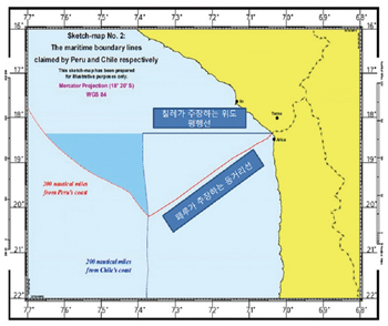 the maritime boundary between Peru and Chile
In 1879, Peru and Bolivia as allies waged a war with Chile over saltpeter and guano, resources creating added value. Chile won the war, taking over some of the southern region of Peru, which included about 38,000 square meters of ocean. This led to the eruption of conflict regarding the maritime boundary between Peru and Chile.
In January 2008, in accordance with the 1948 American Treaty on Pacific Settlement (also known as the Pact of Bogota), Peru brought a case to the International Court of Justice (ICJ), seeking a ruling on: 1) the delimitation of the maritime boundary between Peru and Chile; and 2) Chile's excessive claims of jurisdiction over certain maritime zones. Six years later, on January 27, 2014, the ICJ made the final decision on the delimitation of the maritime boundary between Peru and Chile.
The Claims of Peru vs. Chile and the ICJ's Judgment
Peru's position has been that no agreed maritime boundary exists between Peru and Chile. Noting that the 1947 Proclamations and the 1952 Santiago Declaration were concerned only with exclusive maritime jurisdiction and the 1954 Special Maritime Frontier Zone Agreement between Chile and Peru was nothing more than an agreement concerning fisheries activity, Peru has maintained that the maritime boundary between Peru and Chile should start at the intersection of the land boundary with the Pacific and continue along a line equidistant from the coasts of the two countries. Chile, on the other hand, has argued that there is already an international maritime boundary, tacitly agreed under the 1952 Santiago Declaration, and the maritime boundary between Chile and Peru was confirmed when the countries signed the Special Maritime Frontier Zone Agreement in 1954.
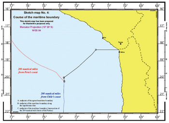
The ICJ defined the course of the maritime boundary between Peru and Chile as follows: 1) The initial segment of the maritime boundary follows the parallel of latitude passing through Boundary Marker No. 1 and runs up to a point (Point A) situated at a distance of 80 nautical miles from the starting point; 2) From Point A, the maritime boundary continues along the line equidistant from Peru and Chile until its intersection (at Point B) with the Chilean EEZ boundary; 3) From Point B, the maritime boundary continues along that Chilean EEZ boundary until its intersection (at Point C) with the Peruvian EEZ boundary. The precise geographic coordinates, however, were left to be determined by Peru and Chile in accordance with the ICJ's judgment "in the spirit of good neighbourliness."
 final decision on the maritime boundary
In order to ascertain whether an agreed maritime boundary exists between Peru and Chile, the ICJ examined the relevant practice of the countries concerned, and analyzed the 1947 Proclamations, whereby Chile and Peru proclaimed exclusive jurisdiction over certain maritime zones, the 1952 Santiago Declaration, and later agreements such as the 1954 Special Maritime Frontier Zone Agreement between Peru and Chile. The ICJ noted that the 1947 Proclamations and the 1952 Declaration contained some elements suggesting that "there might have been some sort of shared understanding between the two countries about their maritime boundaries," and that such mutual understanding needed to be developed. The ICJ observed that there was "tacit agreement" on the single maritime boundary parallel of Boundary Marker No. 1 under the 1947 Proclamations and the 1952 Declaration, and such agreement was "cemented" by the 1954 Agreement. The ICJ further observed that this Agreement gives no indication of the nature or extent of the maritime boundary, except that its provisions make it clear that the maritime boundary extends beyond 12 nautical miles from the coast.
On the basis of the extent of the fishing activities of boats departing from Ilbo and Arica, ports near the Peru-Chile boundary (Marker No.1), in the 1950s, the relevant practices of other countries, and the work of the International Law Commission on the Law of the Sea at that time, the ICJ concluded that the maritime boundary extended to a distance of 80 nautical miles (Point A) from the land boundary. To determine the segment between Point A, 80 miles from Boundary Marker No. 1, and Point B at the 200-nautical-mile limit measured from the Chilean coast, the ICJ applied the three-stage methodology which has been established as the general principle of the delimitation of maritime boundaries today: 1) constructing a provisional equidistance line; 2) considering whether there are relevant circumstances; and 3) conducting a proportionality test. The final segment runs southward from Point B along the Chilean boundary until it reaches the intersection with the Peruvian boundary at Point C.
Fully Review 'Relevant Circumstances' in Case the Three-State Methodology Is Adopted
The 1945 Truman Proclamations empowered those countries in South America, among other regions, to start claiming jurisdiction over 200 nautical miles of ocean off their coastlines. At that time, specific methodologies for the delimitation of international maritime boundaries were not developed yet. Therefore, at the time when Peru and Chile claimed sovereignty over the 200 nautical-mile maritime zones, it was highly likely that the parallel of latitude extending from the land served as a maritime boundary. And this is well demonstrated in the opinion of James Crawford, the counsel for Chile.
However, the delimitation of maritime boundaries by 'estimation' may have extremely weak legal grounds. In this regard, the ICJ's approach, analyzing the fishing activities of the Peruvian and Chilean boats at that time, the national practice of the countries concerned, and the opinion of the International Law Commission, is relatively persuasive. And the fact that the ICJ adopted the three-stage methodology (1) provisional equidistance line; 2) relevant circumstances; and 3) proportionality analysis) shows that this is already a well-established methodology for the delimitation of maritime boundaries today.
The Implications of the ICJ's Ruling on the Maritime Dispute (Peru vs. Chile)
이와The ICJ's ruling on the delimitation of the Peru-Chile maritime boundary has the following implications for Korea. First, considering that a certain matter between two countries engaging in a bilateral action or entering into a treaty could have legal effect if it was tacitly agreed and ascertained in later treaties, we should make our intention clear when entering into treaties. Secondly, since the three-stage methodology adopted in this judgment is well established as the general principle of the delimitation of maritime boundaries, we should fully review 'relevant circumstances,' such as the length of coastlines, when establishing maritime policy with such methodology adopted by international court taken into consideration, in case there are disputes over the delimitation of maritime boundaries between Korea and China or between Korea and Japan. Finally, since the ICJ viewed the Peru-Chile maritime boundary as a single maritime boundary applicable to the water column, the sea-bed and its subsoil, we need to have a strategic review beforehand about which option to choose between the single maritime boundary which regulates both the EEZ and continental shelf together and the double maritime boundary which regulates the EEZ and the continental shelf separately.