동북아역사재단 2010년 10월호 뉴스레터
- Kim, Shin Professor, Kyung Hee UniversityPresident, the Korean Academy of Business Historians
I organize my thoughts on The Hague seminar aboard KLM 1018, on my way home to Incheon International Airport from London with a layover in Amsterdam. I would first like to talk about a little incident at London Heathrow Airport. I was at the check-in counter waiting to get my boarding pass when the machine did not recognize my passport. The KLM staffer was kind enough to bypass the automated system and manually issue me a boarding pass. But that was not the end. I hit another snag with the processing of my luggage. A different KLM staffer took issue with the fact that my personal information could not be located in their database. It was only after a prolonged bout of explanation and verification was I allowed to get on my flight.
Once I get settled in my seat, I reflected on the cause of the mix-up. It suddenly dawned on me that one of the letters in my Romanized name on the boarding pass to The Hague had been different from how it is listed in my passport. The travel agent must have misspelled my name on the reservation form.
The misspelling of an individual's name may lead to quite a fiasco, so it goes without saying how serious an issue it is when the wrong name is used for a sea lying between two nations. What would happen if a distress call is placed using the coordinates of the Sea of Japan by a vessel stranded in the coastal waters of Yeosu, Korea's territorial waters?
Historical evidence is the most important when it comes to disputes between two nations. That is, historical evidence is crucial in proving the logical and objective legitimacy of a nation's claim not just to the other nation involved but also to uninvolved parties.
What's in a name?
Japanese scholars so far have insisted on the name "Sea of Japan" as per the map made by Matteo Ricci in 1602, while Korean scholars have defended the name "Sea of Korea" [Mar Coria], pointing to the map created by Manuel Godinho de Erédia in 1615. At the conference in The Hague, Professor Emeritus Yaji Masata of Japan's Yokohama National University and Professor Watanabe Kohei of Japan's Toikyo University brought up two new claims, one being that the geographical name "Sea of Japan" was used as early as 1568 and the other being that Godinho had used not only "Sea of Korea" but also "Sea of Japan."
Regarding the issue, I had already demonstrated in my paper "10 Models of Mare Orientale (16C-17C)" that the moniker "East Sea" had existed since 1528—40 years before the year claimed for the first instance of the use of "Sea of Japan" by Yaji and Watanabe—as evidenced by Benedetto Bordone's world map. I must admit there is insufficient evidence in my study and that of the Japanese scholars to verify that the monikers "East Sea" and "Sea of Japan," refer exactly to what is the East Sea today. In order to shed some light on the matter, I identified how the East Sea was marked in the ten most notable European maps made between 1528 and 1694 and traced the changes in the geographical naming of the East Sea during the given period.
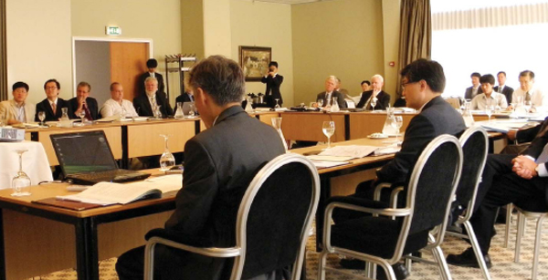
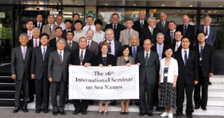
A total of 20 papers from 12 countries were presented fewer than five sub-themes at the international seminar in The Hague. In the first session "Conceptual Reconsideration on Naming Seas," Professor Rainer Dormels of the University of Vienna presented a paper entitled "Practice and Policies in the Use of Binomials, Endonyms, and Exonyms in the Naming of Sea Bodies." The second session was organized under the theme "Naming Seas in the International Framework." Paul Woodman, former Secretary of the United Kingdom's Permanent Committee on Geographical Names and an authoritative figure in the field of geography, presented the paper "The Role of UNGEGN in its First Decade." In the same session, Peter Raper, former Chair of the UNGEGN, presented the paper "Interpreting UN Resolutions on Geographical Names." Thus, Woodman and Raper presented background information and comments on UN-level work on geographical naming. In the same session, President Pak Noh-hyung (Korea University) of the Society for East Sea proposed measures for resolving the issue of the naming of the East Sea from the perspective of international law in his paper "International Norms on Naming Features Common to Two or More States."
Proving the existence of the toponym "East Sea" in 1528 with Bordone's world map
The theme of the third session was "Some Cases of Naming Seas." In the paper entitled "Naming the European Seas," Tjeerd Tichelaar, Editor-in-Chief of Noordhoff Ultgevers Atlas Productions (The Netherlands), provided an expert cartographer's perspective on geographical naming in the overview of the background behind the origin of the name "Arctic Ocean"—a body of water in a similar geographical environment as that of the East Sea.
In the fourth session "A Historical Focus Naming Seas," Professor Lee Sang-tae of the Korea International Culture University of Graduate presented his paper "A Study on 'Chosun Sea' in the Japanese Maps." In the same session, Professor Cheng Long of Beijing Language and Culture University used old Chinese maps—to which Koreans have limited access—in presenting his paper "Yuan Wei (1794-1857), His Research and Maps about East Sea."
In the fifth session "Some Issues of Naming Seas," Senior Research Fellow Kim Yong-hwan of the Northeast Asian History Foundation presented his paper entitled "In the Name of Identity: The East Sea, Not the Sea of Japan." In the sixth session, organized under the theme "The Issue of the Name East Sea/Sea of Japan," Vice President Choo Sung-jae (Kyung Hee University) of the Society for East Sea commented on the measures currently under discussion for resolving the East Sea issue in his paper "Current Status of the Naming Issue East Sea/Sea of Japan." In the panel discussion that followed, Kim Jin-hyeon and Lee Ki-suk, former of the Society for East Sea, along with Co-President Moon Myung-ho of the Civil Coalition for Fairness in Media engaged in a heated debate.
While only 2.8% of maps around the world used both "East Sea" and "Sea of Japan" in 2000, the figure rose to 23.6% by 2007 (and more improvements have been probably made since then). Korea, however, still has the barrier of the remaining 76% of maps around the world to overcome. It is a long way to go, but there is hope. Korea must seek diverse means of expediting the process. While only 2.8% of maps around the world used both "East Sea" and "Sea of Japan" in 2000, the figure rose to 23.6% by 2007 (and more improvements have been probably made since then). Korea, however, still has the barrier of the remaining 76% of maps around the world to overcome. It is a long way to go, but there is hope. Korea must seek diverse means of expediting the process.
One such measure would be enabling a greater number of interdisciplinary studies on the geographical naming of the East Sea. If the issue is tackled by multiple disciplines—e.g. history, geography, maritime history, international law, economic history, marine science, Korea may hasten the process of spreading the correct toponym of the East Sea throughout the world. We started at 2.8%, and we still have 76% more to go.